SHARE:  
This Week's Water Conditions Update

May 31, 2024

Water Conditions Tracker

Lake Okeechobee Levels & Caloosahatchee Flow Impacts

On 5/29/24 Lake Okeechobee was at 13.10 feet, decreasing by 0.32 feet in the past week. The weekly average flow at S-79 was 1,765 cfs (cubic feet per second) and flow from the Lake at S-77 was an average of 1,968 cfs. The 14-day average flow at S-77 was 2,037 cfs. The 14-day average flow at S-79 was 1,980 cfs and has been in the optimum flow envelope (750- 2,100 cfs) for 44 days.

For more information on Lake Okeechobee and estuary conditions go to the latest Caloosahatchee Conditions Report.

Warming Water Temperatures in the Caloosahatchee

& Gulf of Mexico

As the humidity builds and daily temperatures start to rise, it’s clear that summer is quickly approaching in Southwest Florida. While these environmental changes are expected annually, a new seasonal trend may be on the rise — warming temperatures in the Caloosahatchee and the Gulf of Mexico. 

Read More

Water Surface Temperature

This Week

Daily Average for May 29, 2024


Gulf of Mexico: 88.5°F

Caloosahatchee (Alva): 88.8°F

Lake Okeechobee (Polesout3s): 85.5°F


Last Week

Daily Average for May 22, 2024


Gulf of Mexico: 86.3°F

Caloosahatchee (Alva): 87.8°F

Lake Okeechobee (Polesout3s): 83.3°F


Weekly Rainfall Totals

WP Franklin (S-79): 0.25" Ortona (S-78): 0.00" Moore Haven (S-77): 0.86"

Virtual Water Quality Tour from Lighthouse Beach Park

Click here or on the image above to take a virtual tour from above Lighthouse Beach Park to see how the water looked this week. Photo was taken on 5/30/24 at 1:08 PM on a rising tide (1.6 ft). The 14-day average flow at S-79 was 1,992 cfs.

Red Tide

On 5/24/24, the FWC reported that the red tide organism, Karenia brevis, was not observed in samples collected statewide over the past week. 

Blue-Green Algae

On 5/28/24 sampling for cyanobacteria by the Lee County Environmental Lab reported moderately abundant Dolichospermum, Microcystis and cyano filaments at the Alva Boat Ramp as streaks and some small clumps and upstream of the Franklin Locks as streaks with some accumulation along the lock. Some streaks of Dolichospermum and Microcystis were present at the Davis Boat Ramp.

On 5/30/24, satellite imagery from Lake Okeechobee showed the presence of an algal bloom on 200 square miles (42%) of the Lake.

Become a Citizen Scientist and Get the Algae Reporting App Today!

SCCF wants to know when and where all types of algae sightings occur to monitor conditions around the islands and to investigate algae bloom occurrence with patterns in seasonal weather changes and Lake Okeechobee water management practices.


Click on and bookmark this link to report an algal bloom sighting.

Resources To Follow:

To learn more about our current water conditions, click on the following links:


Water Quality Dashboard


Water Quality FAQ

Find answers to some of our most commonly asked questions regarding water quality and more.


Water Conditions Update Archive


Caloosahatchee Conditions Report

A collaborative, weekly analysis, including recommendations for water managers regarding Lake Okeechobee flows.


RECON

SCCF's River, Estuary, and Coastal Observing Network is a network of eight optical water quality sensors deployed throughout the Caloosahatchee and the Pine Island Sound estuary to provide real-time water quality data.


Caloosahatchee River Virtual Tour


Red Tide Resources


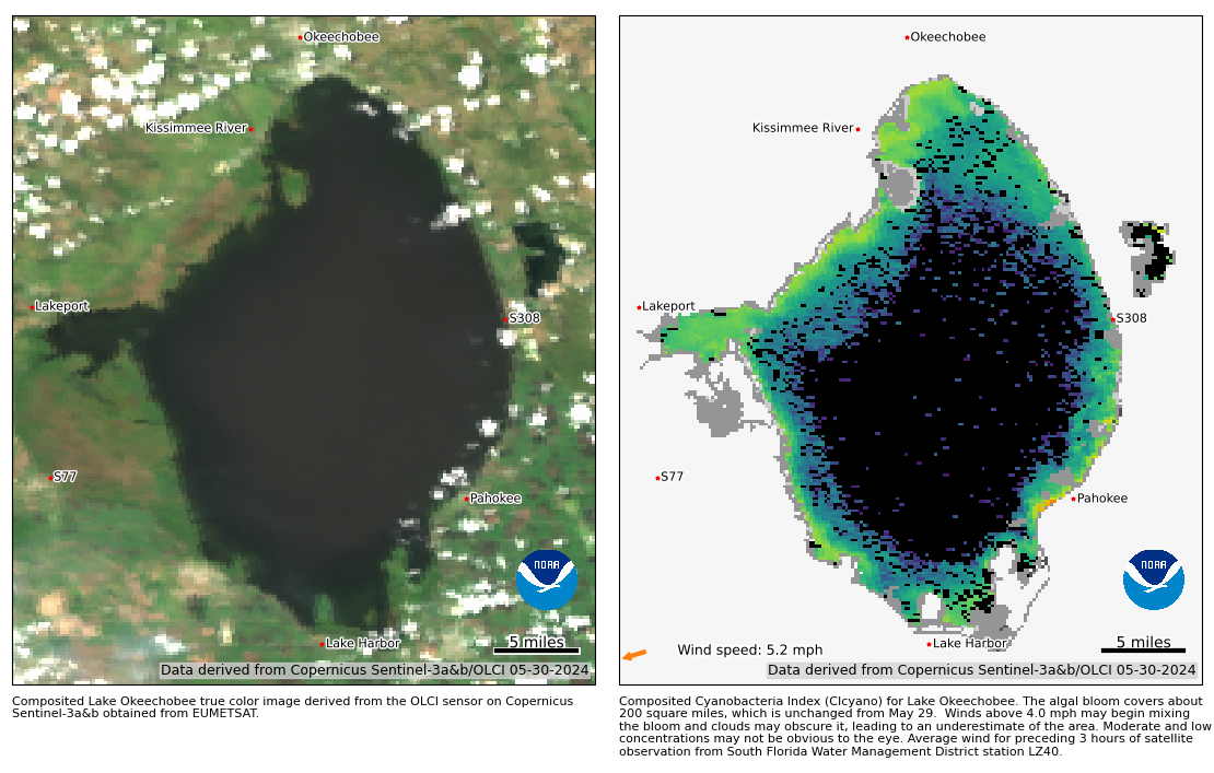
NOAA HAB Monitoring System - Lake Okeechobee

Click here to subscribe to the Weekly Water Conditions Tracker


Click here to subscribe to Connecting You to SCCF and other SCCF mailing lists.

LinkedIn Share on LinkedIn
DONATE TO SCCF
Stay Connected!
Facebook  Instagram  Youtube