Roving Ranger Events

for August 16-18

Who Are the Roving Rangers?

The Flagstaff area Roving Rangers is a partnership team comprised of both rangers and volunteers from the National Park Service and the U.S. Forest Service. The Ranger’s mission is to provide fun and free ranger programs in and around the Flagstaff area, in the three local national monuments, and the Coconino National Forest. The Rangers bring understanding and inspiration to all ages, prompting visitors to cherish our natural world, and conserve natural and cultural resources. Check out Our Webpage and follow us on Our Facebook Page to stay up to date with what we're doing!

Here's what's going on this week:

Every week the Roving Rangers provide special programming around the Flagstaff area of the Coconino National Forest. You are receiving this email because at some point in time expressed interest in learning more about the us. Here's what's going on this week:

Friday August 16

ARIZONA SNOWBOWL: The Scenic Gondola Ride is open every day, weather permitting. On Fridays, Saturdays, & Sundays throughout the summer, Roving Rangers are there from 10am-4pm to greet you up top, and to provide interpretation and short presentations. Contact AZ Snowbowl @928.779.1951 for Scenic Gondola Ride details.

Saturday August 17

Morning Flag Library & Roving Ranger Guided Hike at Little Spring

9:00am–12:00pm Roving Flag Librarians & Rangers team up to lead this short-but-lovely hike to C. Hart Merriam's 1889 base camp at Little Spring. For details, visit this webpage: flagstaffpubliclibrary.libcal.com/event/120982

Critter Program at Pine Grove Campground

4:00–5:00pm. Join Ranger Barbara to explore and learn about critters and other things that live in the forest! Fun activities for kids and adults of all ages! Meet at the amphitheater parking lot. Bring camp chairs or plan to sit on the soft pine needles for part of the time!

Sunday August 18

Jr. Ranger Program at Bonito Campground

9:00am-10:30am. Join Ranger Barbara for a fun and interactive session on how to become a Coconino National Forest Jr. Ranger. Booklets and Badges are available upon completion!

Reverence for a Ranger

Roving Ranger Richard


Did you know Roving Ranger Richard volunteers for several organizations that nurture appreciation of the past? And he was just honored for all he does.


At last week's Pecos Conference, VVAC's very own Richard McGaugh was this year's recipient of the Alexander J. Lindsay Jr. Unsung Hero Award. This award is given for tireless work behind-the-scenes that is critical to the success of archaeological, anthropological or historical research projects and/or publications. We are immensely proud of Richard for his recognition!

Richard McGaugh is from a fourth-generation Verde Valley family and has spent his time studying and exploring Central and Northern Arizona. Richard is a VVAC Docent and Hike Leader and has led countless excursions for us. He is also a VIP Interpretative Ranger at Walnut Canyon National Monument and Wupatki/Sunset Crater National Monuments. Richard also serves as a Docent at the Museum of Northern Arizona.


Great work Richard! So glad that you are part of our Roving Ranger Crew!

Ask A Ranger Column

Every week the Roving Rangers consult with experts in the area to cover a pertinent topic of interest and publish it the Arizona Daily Sun on Thursdays. If you have a question that you would like to submit, please email: askaranger@gmail.com.

Oak Creek Canyon I: The Geology by Wayne Ranney

Published in the Arizona Daily Sun on August 8, 2024

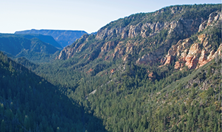
Driving south from Flagstaff on Highway 89A, I often stop at the Oak Creek Vista Overlook to admire Oak Creek Canyon. This is probably the most splendid and well-known of the dozens of streams and canyons carved into the long, southern edge of the Mogollon Rim, perhaps because it is the only one with a paved highway running through it.

             From the Overlook, you can see that the rim of the canyon to your right (west) is much higher than the opposing rim on the left (east). This is because Oak Creek Canyon was carved along a fault that raised the west side about 1,000' relative to the east side. Melted snow on the Coconino Plateau infiltrates the rocks and then flows along the fault to the south to supply the water in Oak Creek. Huge floods have aided in the excavation of the canyon as well.

             From the Overlook, the canyon's western rim is capped by Kaibab Limestone. The Kaibab

is present on the eastern side as well, but is

capped by basalt lava flows, both at lower elevations being offset by the fault. The basalt flows erupted from vents near Munds Park; I-17 between Munds Park and State Highway 179 takes advantage of the gently sloping surface of the lava flow, which acts as a ramp into the Verde Valley. The lava flows are as young as 6 million years and are broken by the fault farther south. This means that the carving of Oak Creek Canyon is younger than 6 million years. 

Leaving the Overlook and descending 89A through the “switchbacks,” you may notice a few very thin red beds between the dark gray lava rocks. These are ancient soils (called "paleosols") that developed on the surface of an older lava flow before the next one flowed over and buried it. It’s incredible to think that tens of thousands of years could have passed between each individual lava flow, giving plenty of time for soil to develop. Heat from the encroaching lava flow incinerated any vegetation that was growing on the soil. 

Continuing south through the switchbacks, you will approach and then cross the Oak Creek fault two times in the hairpin turns that veer to the left. Visually, the fault is not that impressive being only a wide zone of inconspicuous crushed rock, pulverized with each incremental movement

of the fault. Sometimes the most impressive geologic features are the ones hardest to recognize, with the knowledge associated with such features providing the awe and wonderment. 

Upon reaching the canyon floor, you will closely follow Oak Creek all the way into Sedona. At first, the cool and shaded spruce/fir forest obscures the rocks. But as the creek chisels deeper, the canyon gradually becomes wider, sunnier, and less covered in vegetation. By the time you are at Cave Springs Campground and the West Fork, you see the first outcroppings of the red Schnebly Hill Formation. You have arrived in Sedona’s famous Red Rocks!

             The Schnebly Hill Formation is unique in that it is not present at Grand Canyon but is 700–1,000 feet thick in the Sedona area. It records a time when sand dunes migrated along the shore of an ancient seaway. The red color comes from tiny grains of mica and other iron-rich minerals that sparsely populate the dominantly white quartz sandstone. When groundwater seeps through the rock, it dissolves some of the iron that then places a very thin coating of red over each sand grain.

             From the top of the canyon to about Indian Gardens, water from springs increases the flow of

Oak Creek. Just below Indian Gardens, the Oak Creek fault veers to the east for one mile, then takes a 90° turn to the south, passing east of Munds Mountain. To the south of these jogs of the fault, Highway 89A plunges headlong between towering cliffs of the Schnebly Hill Formation, now on both sides of the highway. Passing Grasshopper Point, be sure to take in this expansive and impressive view.

             When you finally arrive in Sedona, you will have just driven the most scenic 15 miles of roadway. In fact, this was Arizona’s first officially designated Scenic Road, listed in August 1984. 

Wayne Ranney completed a Master’s degree at

NAU centered on the House Mountain volcano near Sedona. He is the author of "Sedona Through Time.”

Have Questions? Interested in joining the Roving Rangers? Please contact Mike at: michael.kruse@usda.gov