State Success Story
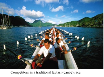
The American Samoa Coastal Program connects local traditions to environmental stewardship, inspiring villages to take actions that improve and protect their coastal resources.
To learn more, please
click here.
|
At the Agencies
EPA announced the availability of approximately $1 billion in credit assistance for water infrastructure projects under the new Water Infrastructure Finance and Innovation Act (WIFIA) program. EPA's WIFIA program will provide long-term, low-cost credit assistance in the form of direct loans and loan guarantees to creditworthy water projects.
WIFIA provides another option for financing large infrastructure projects, generally at least $20 million, in addition to the State Revolving Funds and bond market.
Read more
The Bureau of Ocean Energy Management (BOEM) has announced a Memorandum of Agreement (MOA) signed between the Bureau of Ocean Energy Management (BOEM) and the United States Army Corps of Engineers (USACE), Mobile District. The agreement will be a key component in support of the long-term recovery of the Mississippi Gulf Coast from the devastation caused by Hurricane Katrina and other storms. This project will take up to 19.6 million cubic yards of sand from ten Outer Continental Shelf (OCS) locations-the largest volume of OCS sand conveyed by BOEM's Marine Minerals Program to date-to restore Ship Island within the Gulf Islands National Seashore in Mississippi, which is under the jurisdiction of the National Park Service (NPS).
Read more
|

In the News
Every coastal state's coastal management program (federally approved by the US Secretary of Commerce) is required to provide a coastal atlas that allows the public to see where the Coastal Area Boundary is located, as well as other designated coastal areas. In New York this includes Significant Coastal Fish & Wildlife Habitats (aka SigHabs) and Scenic Areas of Statewide Significance (SASS).
The coastal atlas has been upgraded over the past decade to a static online map, with limited functionality to a fairly reasonable mapping application that allowed address search and access to other boundaries such as communities with approved Local Waterfront Revitalization Plans, federal lands, and Tribal lands, but it was a separate application requiring care and attention. The coastal atlas can be accessed the same way it has been through the Office of Planning & Development's home page, in the Publications and Tools section under the Coastal Area Boundary Map and clicking on the image of the relief map of New York, all the expected layers are added to the map viewer.
Read more
Last year was the hottest on record, two federal agencies confirmed Wednesday morning, after months of warning that 2016 would be another chart-buster. Findings from separate analyses by NASA and the National Oceanic and Atmospheric Administration mark the
third consecutive year that the planet has experienced record-high temperatures and the
40th consecutive year that global temperatures were above average in more than a century of record-keeping.
Read more
|
In the States and Regions
East Coast
Port Canaveral commissioners on Wednesday (Jan 18) will consider an initial step in what could be up to a 10-year process to deepen the port's channel to handle larger cargo ships.
Port staff is recommending commissioners approve spending nearly $1.4 million on two related projects.
Read more
A federal agency said Tuesday it is offering 191 square miles in the Atlantic Ocean for a commercial lease to develop an offshore wind farm off Kitty Hawk. The announcement by the U.S. Bureau of Ocean Energy Management marks more than six years of research and analysis for developing an industrial-scale wind farm off North Carolina's coastline.
Read more
Gulf Coast
A new study by Louisiana scientists indicates that exposure to salt water leaves coastal wetlands less capable of battling sea level rise. The paper, produced by scientists at the Baton Rouge-based Water Institute of the Gulf, has implications for Terrebonne and Lafourche, where freshwater marshes have long suffered erosion partly because of saltwater intrusion from the Gulf of Mexico.
Read more
A plan to potentially deepen the Belle Pass entrance to Port Fourchon from 26 feet to a possible 50 feet was publicly outlined today (Jan 16) as the process to get government approval begins. Chett Chiasson, executive director of the Greater Lafourche Port Commission, said a master plan the commission enacted in 2015 noted further development of Belle Pass as a key part of ensuring the future of Port Fourchon.
Read more
West Coast and Pacific Islands
The erosion and potential solutions to stabilize the shoreline at the North Jetty drew special attention from the Ocean Shores City Council on Monday. The decades-old problem has led to the completion of the Grays Harbor North Jetty and Ocean Shores Shoreline Erosion Study, which suggests several options the city has put forward with partners such as the state Department of Ecology, the Port of Grays Harbor and several state lawmakers.
Great Lakes
Bioengineering is defined by the Michigan Department of Environmental Quality (DEQ) as "using a combination of native planting and natural, or biodegradable materials to provide shoreline protection." It also is often referred to as softshore engineering or lakescaping. This method is designed to provide a stable shoreline by protecting the shoreline from waves and erosion while at the same time improving ecological features and the integrity of the shoreline.
Read more
The Michigan Departments of Environmental Quality, Natural Resources and Agriculture and Rural Development today (Jan 12) announced that 17 grant projects will share $3,507,907 in funding through the Michigan Invasive Species Grant Program. It's an initiative launched in 2014 to help prevent and control invasive species within the state. The program targets four key objectives:
- Preventing new introductions of invasive species through outreach and education.
- Monitoring for new invasive species and the expansion of existing invasive species.
- Strategically managing and controlling key colonized species.
- Responding to and conducting eradication efforts for new findings and range expansions.
Read more
|
|
Announcements & More
Coastal GeoTools 2017
The Coastal GeoTools conference, established in 1999, is typically held every two years and focuses on geospatial data, tools, technology, and information for coastal resource management professionals. Coastal GeoTools 2017 will be the ninth in the conference series.
The Coastal GeoTools 2015 conference attracted nearly 300 attendees from all over the U.S. and several foreign countries. Coastal professionals from many different sectors find the networking opportunities of the conference unique and important for furthering the goals of their organizations. Anyone interested in the development and application of geospatial technology for management of coastal resources will benefit from this conference.
Save the Date: Workshop on Best Management Practices for Atlantic Offshore Wind Facilities and Marine Protected Specie
BOEM's Office of Renewable Energy Programs is hosting a three-day "Best Management Practices Workshop for Atlantic Offshore Wind Facilities" on
March 7- 9. The workshop will discuss best management practices for preventing, reducing, and monitoring impacts to marine protected species from the development of offshore wind on the Atlantic Outer Continental Shelf.
The workshop will take place at:
NOAA Fisheries
Building 4 (Science Building)
1315 East-West Highway
Silver Spring, MD 20910
OneNOAA Science Seminars, 2016
Title: Protecting our Marine Treasures, Sustainable Finance Options for U.S. Marine Protection Areas
Date & Time: Thu, February 9, 2017, 1pm - 2pm
Title: Following my Dreams
Date & Time: Thu, February 23, 2017, 11:30am - 1:00pm
Seminars are open to the public. For remote access, location, abstracts and more, visit the OneNOAA Science Seminar Calendar at:
http://www.nodc.noaa.gov/seminars/
Seminars are posted in Eastern Time and subject to changes without notice; please check the web page for the latest seminar updates.
Events & Webinars
January 25 - 26, 2017
February 6 - 9, 2017 - Early registration ended on November 23
March 14 - 16, 2017
March 20 - 23, 2017
May 9 - 11, 2017
May 31- June 2, 2017
|
|