Volume 97 | Tuesday, July 2, 2024

Jump Seat Logo _New_.png

The 2024 Hurricane Season

Welcome back to Jump Seat. This week, we’ll review the 2023 Atlantic hurricane season and look to the upcoming 2024 season, focusing on how this season might impact your operations. 

The 2023 Atlantic hurricane season officially concluded in late October with a total of 20 named storms, three of which met major hurricane criteria. The season took fourth place in the ranking for the most active cyclonic development, likely fueled by record-breaking Atlantic sea surface temperatures (SST). Thankfully, only a few storms had direct impacts to land. Most notable in the U.S. was Hurricane Idalia, a super-destructive Category 4 that made landfall in the Big Bend region of Florida. ATC services came to a near halt at several major terminals across Florida on August 30 as the storm progressed across the Sunshine State – including ‘ATC Zero’ at ORL, JAX, PIE, and TPA.

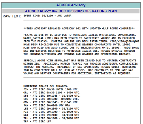
Image 1: ATCSCC Operations Plan from August 30, 2023, highlighting the operational impact of Hurricane Idalia across Florida.  


When impending weather events are forecast to significantly impact some of the larger markets, Traffic Management Coordinators at the FAA will hold additional Telcon meetings to discuss operational impacts, including airport and route closures across the U.S. and Caribbean. As an active member of the FAA Collaborative Decision Making (CDM) program, ARINCDirect Flight Coordinators and Meteorologists attend these special meetings to gather and exchange pertinent information for our operators during these events. 


The Atlantic hurricane season officially begins June 1st and lasts through November 30th. Operations throughout the Atlantic, Caribbean, and Gulf of Mexico are frequent during these summer travel months. It’s thus important to remain vigilant for potential for weather disruptions throughout this season.  


There are three main ingredients needed to develop these systems into stronger hurricanes. Minimum sea surface temperatures (SSTs) typically need to be 80°F (27°C) to act as fuel for the storms. Moist air needs to be available in the system to help build it. And finally, wind shear needs to be at a minimum to keep the storm from being shredded apart or toppling over itself. 


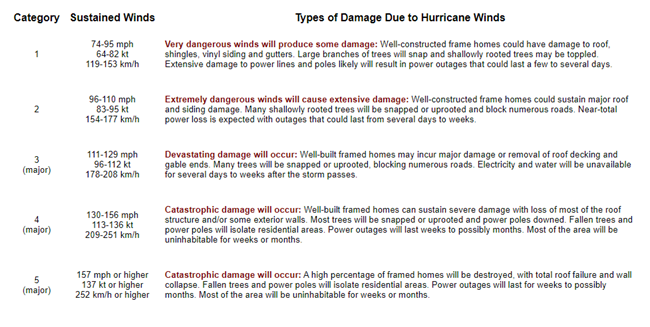
This year we can anticipate an 85% chance of having an above-normal hurricane season, according to the National Oceanic and Atmospheric Administration (NOAA). This is a combination of the current climate situation coupled with a transition into La Niña conditions. La Niña tends to bring more tropical activity to the Atlantic basin due to a lesser amount of wind shear in the tropics. The Caribbean and Atlantic are also seeing high SST. The opposite can be said for the Pacific Ocean basin, where La Niña conditions are likely to show a less active hurricane season for that region of the world. NOAA, the National Hurricane Center (NHC), and Colorado State University (CSU) all work together to create these forecasts each year. For the 2024 season, these organizations predict between 17 and 25 named storms, with between 4 and 7 reaching major hurricane status. To reach major status, the storm needs to be classified as Category 3 or higher out of the 5 categories in the Saffir-Simpson Hurricane Wind Scale. The image below explains in detail the different levels of criteria per category of hurricane strength.

Image 2: Saffir-Simpson Hurricane Wind Scale explanations for the 5 hurricane categories, per the National Hurricane Center (NHC). 

Image 3: 2024 Atlantic Tropical Cyclone names courtesy of the National Hurricane Center (NHC). 


As of this writing, the 2024 hurricane season is already off to a record-breaking start, already claiming the title for the earliest recorded Category 5 hurricane as Beryl sweeps through the Caribbean. Even though hurricanes of this strength are rare, it’s even more historic due to its development before the Independence Day holiday. The vast majority of storms of this nature have historically formed in the later summer months of August and September when environmental conditions across the Atlantic are more favorable for their development. 


To best plan for flights across the Gulf of Mexico, Atlantic, and Caribbean this summer, checking the weather daily is vital. Any initiation of a surface low-pressure system off the western coast of the African Saharan region can lead to these huge storms down the line. Again, this is because there is little wind shear in that region and a plethora of warm water to fuel growth. 


Hurricane forecasts are ever-evolving, making it difficult to forecast days in advance with changing models. Thankfully, ARINCDirect's team of meteorologists and flight coordinators are ready 24x7 to assist you throughout this hurricane season!

Did you know?

  • The Watchers: The United States has two organizations that perform surveillance, research, and reconnaissance missions directly into cyclones. The United States Air Force Reserve’s 53rd Weather Reconnaissance Squadron (WRS), alongside the National Oceanic and Atmospheric Administration (NOAA)’s Hurricane Hunters, collaboratively work to obtain pertinent weather observations that satellites and other ground-based technology (i.e., radar) are not able to detect. Meteorological parameters, including center sea level pressure (SLP), wind, temperature, and dewpoint at relevant FLs, are just a few pieces of the real-time data that improve forecasting at the National Hurricane Center (NHC). 
  • The Fleet: Much like many of the aircraft in our database, the NOAA Hurricane Hunters utilize the Gulfstream IV-SP (nicknamed “Gonzo”, registration N49RF) for their reconnaissance missions. One of the most useful tasks aboard the aircraft is the use of a GPS dropsonde. This cylindrical instrument dropped from the aircraft vertically profiles the atmosphere, measuring and transmitting valuable data on its descent back to Earth. The aircraft is also outfitted with a Tail Doppler Radar (TDR) on the rear of the aircraft, providing cross-sectional images of the storm. The Hurricane Hunters also operate two Lockheed WP-3D Orion's, nicknamed “Kermit” (N42RF) and “Miss Piggy” (N43RF). The 53rd WRS primarily operates ten Lockheed WC-130Js. 

Useful Links

Thank you for reading!

Sign up for Izon today!

Izon offers a free, secure, single sign-on experience

that combines the best of ARINCDirect into

one connected platform

Izon Setup Guide
More Jump Seat
ARINCDirect Support