Walking & Biking News & Ideas
|
|
We hope you are staying healthy!
The first signs of Spring are everywhere. The trees are blooming, green, tender new grass is blanketing the yards and hills, and the bright orange California poppies are starting to open. We have a great trail review of a local hidden gem to coax you outside to enjoy the sunshine. This newsletter is focused on "Complete Streets" - the improvements being made at Bubb Road, a discussion of how an Active Transportation plan can transform a city, and a real-life example of what Mayor Pete was able to achieve in his hometown of South Bend and the lessons it holds for our city. Read on!
|
|
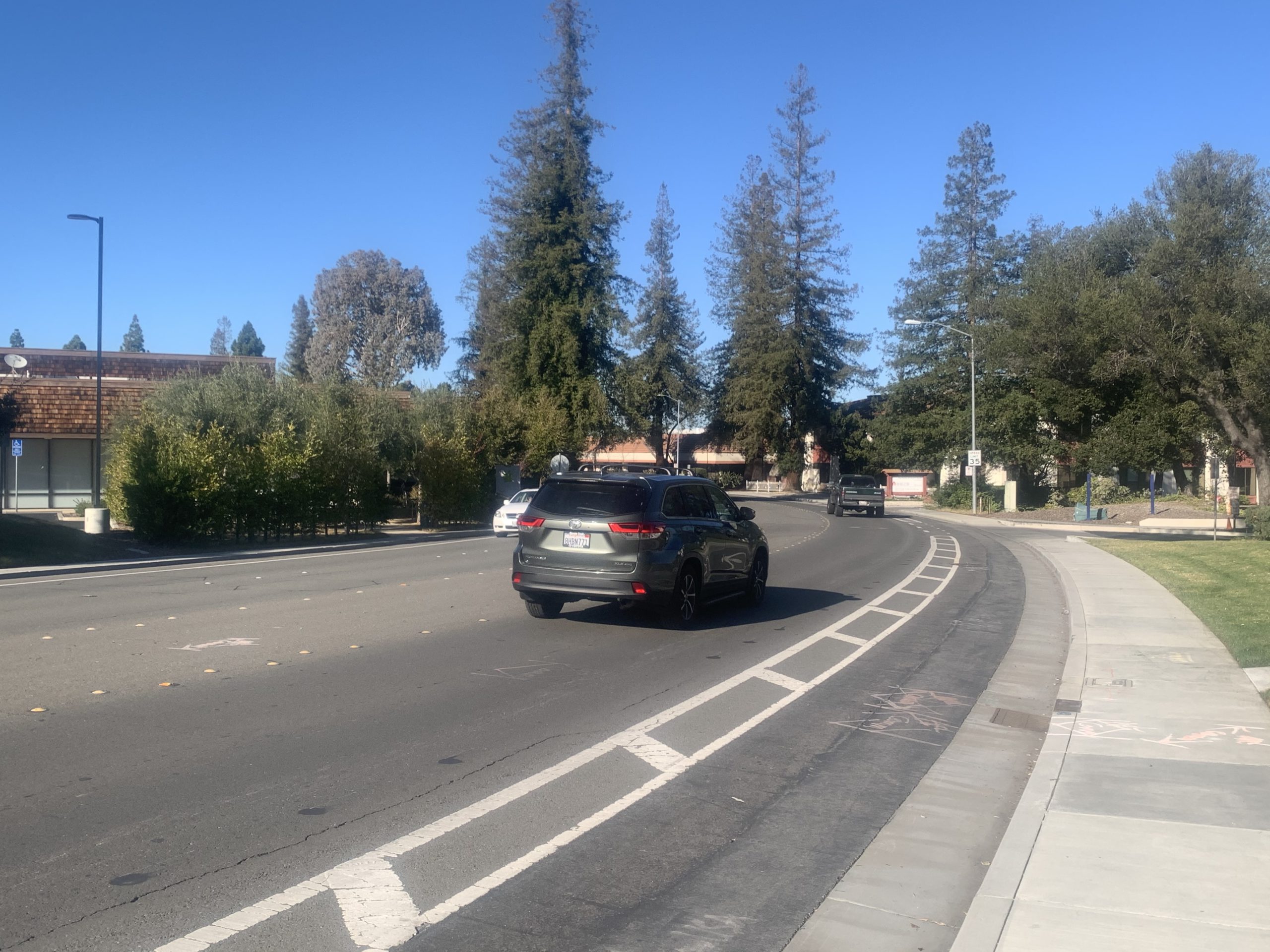
Major changes coming on Bubb Road to make a "Complete Streets" design
|
|
At the February 2, 2021 Cupertino City Council meeting, the Council approved a contract with Granite Construction to re-engineer Bubb Road. The changes will extend from Results Way to the South (close to McClellan Road) to the Stevens Creek Boulevard intersection near the Cupertino Post Office. The $775K contract stipulates that construction will begin in March 2021. The project plans are shown above.
Major features of the project will include:
- Physically separated (with barriers) Class IV lanes along both sides of Bubb Road between Stevens Creek Boulevard and McClellan;
|
|
Current Bubb Road configuration |
|
10 ways Active Transportation can dramatically improve Cupertino |
Active Transportation is human-powered transportation. It re-invents city planning to make our cities healthier, more enjoyable, and more dynamic.
Implementing an Active Transportation Plan (ATP) can dramatically transform the way we live our lives in 10 ways:
|
- Safer streets for pedestrians and cyclists
- Healthier residents
- Stronger local economy
- Higher property values
- Tighter-knit community
- Cleaner air
- Less traffic congestion
- Lower cost of living
- Reduced city infrastructure costs
- Increased corporate investments in the city
|
|
Cupertino was designed in the 1950s and 1960s when the love affair with cars was at its strongest – wide car-friendly streets, narrow or non-existent sidewalks, no connections between neighborhoods, and an expectation that a car was required for all activities.
Currently, half of the trips residents take are within range of a 20-minute bike ride, with more than one-fourth within range of a 20-minute walk. Yet the vast majority of even these short trips are taken by car. Read more...
|
|
Cupertino Bike and Ped project updates
- The Linda Vista Trail construction is in progress.
- The Regnart Creek Trail construction is in progress. Expected completion is December 2021. No fence contractors have been designated yet.
- Stevens Creek Blvd Class IV separated bike lanes (Wolfe to Tantau) are now substantially complete.
- Wayfinding signs continue to be fabricated and placed by Street Division staff.
- School Walk Audit improvements phase 1 (smaller projects) at various locations have been completed and larger projects are being bundled for construction.
- Upgrades of traffic control cabinets are occurring at major intersections in Cupertino.
- The Mary Avenue project has been designed, but is paused until Mary Ave. is resurfaced this Spring/Summer.
- Design work for the Stevens Creek Blvd Phase 2 (Wolfe to I-85) Class IV bike lanes is underway.
- Design of the McClellan / De Anza Intersection improvements is in progress.
- Design for the Junipera Serra (I-280) trail is in progress.
- Bollinger Road Corridor Safety study is on hold until traffic resumes to normal volumes.
|
|
How Pete Buttigieg transformed South Bend streets
Downtown South Bend, Indiana was a drive-through city center with multiple lanes of traffic, focused on moving cars through as fast as possible. Sounds familiar? Here in Cupertino, we have turned over Stevens Creek Boulevard and De Anza Boulevard primarily to cars, with pedestrians and bicyclists relegated to the edges. We hear a common pushback that these streets need to remain this wide, this choked with cars because they are major thoroughfares for the valley. But we can do better for our residents than to be a drive-through city for valley commuters.
|
|
When Pete Buttigieg -- our new Secretary of Transportation in the Biden administration -- took office as mayor of South Bend in 2012, he kicked off a $25M project to transform their downtown from a drive-through area for cars to a "Complete Streets" destination welcoming for all residents, pedestrians, and cyclists.
The city reduced the number of driving lanes from four to three, added bike lanes, extended sidewalks at intersections to make streets easier to cross, and installed roundabouts. South Bend downtown business leaders say the benefits have been dramatic, with more people spending time and money in the area.
We encourage you to reach out to Cupertino City Council and tell them we deserve “complete streets” that balance the needs of pedestrians and cyclists with those of drivers.
|
|
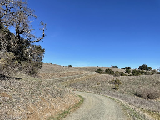
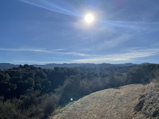
Fremont Older Open Space: a hidden gem
By Christian Lei, Walk-Bike Cupertino Boardmember
|
|
My favorite thing to do when I want to get outside but not travel far from home is go to Fremont Older for a hike. Fremont Older is administered by the Midpeninsula Regional Open Space District and is nestled in the hills south of Cupertino and Saratoga. The trails are open to hiking, biking and horseback riding. The space used to be owned by the Garrod Family, which still runs a horse ranch on the southern side of the land. In the 1980s, the land was gifted to the Midpeninsula Regional Open Space District by the Garrods for us to all enjoy. The highest part of the park is called Masie’s Peak which is named after Masie Garrod in honor of their donation. |
While I consider this park a hidden gem, parking can be difficult depending on when you come. On weekends, expect to wait for a spot in the Prospect parking lot or park at the base of the driveway for a short walk and no wait. Do not park outside of the lot where it says no parking, or you will be ticketed. From the Prospect lot, you can either walk up the driveway or up the path to get to the views. Once you pass through the tree line, the views are stunning, and you can see the entire Silicon Valley from the hill. Read more...
|
|
Kennedy Middle adds sustainability to science classes with Safe Routes lessons |
|
Every summer, San Mateo County Office of Education hosts an Environmental Learning Collaborative (SMELC) where they train teachers how to integrate sustainability topics into their curriculum. This past summer, a transportation component was added to the training, with an emphasis on transportation impacts on the environment and Safe Routes to School as part of the solution.
As it turns out, both Kennedy Middle School science teacher Susan Hansen and Cupertino Safe Routes to School Coordinator Cherie Walkowiak both attended the SMELC sessions this summer, and a great collaboration began. Ms. Hansen incorporated the SMELC transportation component into her 8th grade science classes this fall as part of her yearly Climate Unit. Ms. Hansen taught students about the environmental impact of vehicle emissions and how they can make a positive impact on the planet by making climate-friendly transportation choices such as walking, biking transit and ridesharing. read more...
|
|
If you enjoyed this newsletter,
please encourage your friends or family to sign up too!
Walk-Bike Cupertino never shares or sells any personal information.
|
|
We'd love to hear YOUR voice!
Do you know a great walk, ride, run or hike? Want to share an issue about walking, biking, city planning, or interesting idea?
Walk-Bike Cupertino would love to spotlight it in our newsletter and on our website! Articles should be 500 words or less, and should include a picture (at least 3 pictures for hikes). All submissions are subject to approval & editing, and can be used by Walk-Bike Cupertino in future publications. Contact us here.
|
|
Happy Walking and Biking,
Your friends at Walk-Bike Cupertino
Find much more, including maps, safety data, and information on all the city projects at: walkbikecupertino.org
|
|
|
|
|
|
|